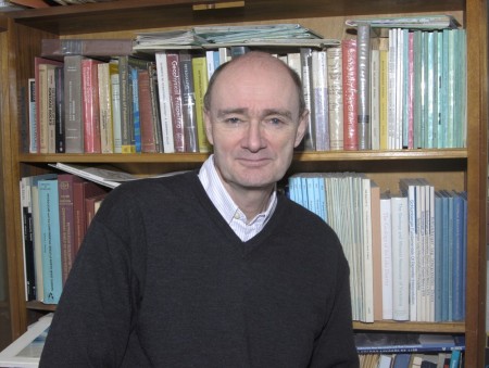
Professor Dave Tappin, British Geological Survey
How did you got into your job?
Early in life I was always interested in the natural environment and, when I grew older, in travelling to exotic places. When I was young, I was fascinated by the sea, made model ships – especially sailing boats, and even wanted to join the Royal Navy. As I grew older I studied the natural sciences, but was also interested in geography. When I chose my A-level subjects I was able to study geology as well as the other sciences – this was when I knew what I wanted to do. So I read Single Honours Geology at University and then was offered a Masters in Marine Earth Science at University College, London. From there I joined the Marine Geology Group at the British Geological Survey (BGS). After ten years with BGS mapping the UK Shelf I was seconded to Tonga, in the Pacific, where I spent five very exciting years. On my return to BGS I continued to work in the Pacific researching geohazards, especially tsunamis, and also working on projects in the UK. The culmination of my UK shelf work is undoubtedly the Humber REC mapping because it addresses all aspects of the natural marine environment. Multidisciplinary projects are always the most exciting because of the variety of data used and the different personalities involved.
What do you do on a day-to-day basis?
Everything, from initiating and planning projects, acquiring data at sea, processing the data and, finally, publishing the results. My research portfolio includes UK shelf mapping and marine geohazards. For the past two years I have been Project Manager for the Humber REC, and this has taken up most of my time. As well as being the Project Manager I have been intimately involved in the science; being ‘hands on’ is what I like. For the Humber I was directly in researching and writing up the tender, working on the Desk Based Study, planning the marine surveys and interpreting the data. Of course I didn’t do this all on my own! I was fortunate to have a really good team of other geologists, archaeologists and biologist, that I really enjoyed working with. Outside of UK shelf geology my other speciality is research into tsunamis, particularly those sourced from submarine landslides and volcanic collapse. Studying tsunamis has taken to me to all parts of the world and I have carried out marine expeditions in all the worlds’ great oceans. I have been to the Indian Ocean four times to study the devastating 2004 tsunami. In fact I was aboard the first research vessel to survey the earthquake zone in January 2005; and in May 2005 the BBC/Discovery even made a television documentary of one of my expeditions. Before Christmas I was mapping tsunami deposits in Hawaii. The marine group in BGS is quite small, so there is very little discrimination in what the scientists do, whatever their grade. Thus we all have to share the boring jobs, as well the exciting stuff too. In fact all the work is interesting because the end result is that we know a little bit more about the environment.

Investigating the Tsunami: Emerging from a Japanese submersible after diving 1500 metres under the sea off the coast of Papua New Guinea
What is your favourite part of the job is?
I enjoy all aspects of my work. But I guess my favourite job is working on multibeam bathymetry data, processing it, gridding it and then interpreting the results. Over the past 10-15 years mapping the seabed has become just like mapping on land – the 3D imagery now available allows the interpretation of sea bed morphology undreamed of when I started out as a scientist. Technology, such as GPS allows us to locate our data with centimetre accuracy and computers allows us to acquire and process huge volumes of data. This data allows us now to understand marine processes as well as those onland. As well as using multibeam data I also enjoy formulating new scientific ideas and writing up the results. It is really rewarding when, after months of hard work and often a battle with reviewers, a research paper is at last published in a scientific journal. This always provides a great stimulus to move on to the next challenge. I am also very lucky in that I teach a Masters course in geohazards at University College London; the interaction with a lively group of young scientists is always stimulating.
What skills/qualifications are useful for your profession?
When I became a geologist there was a great emphasis on observational skills. For a geologist, field mapping, the observation of landscape and its relation to the underlying sediments and the ability to visualise in three dimensions, was fundamental. Since then it has become increasingly necessary to have maths-based skills, for example in the acquisition and processing of marine geophysics data. However, to my mind geology is almost unique in requiring a very broad set of skills to be a successful. I believe that the best geoscientists think differently to other scientists. The skills required to do this include; an ability to learn from field based observations, laboratory studies of field samples, an awareness of the long timescales over which Earth processes take place, a realisation that the Earth is a very complex system, an awareness of spatial thinking and an ability to put all these different data sets together to achieve a broader understanding. Not all of these skills always reside in one person, so to be successful you have to realise some of them, be good, if not expert in others, and also to be prepared to discuss openly with others the observations and skills you don’t possess. It does help to have a few qualifications too to get you foot on the ladder; after that it is opportunity, luck and ability. Hard work helps.
Any other career tips?
Be proactive and work with people you get on with, this may not help your advancement but it makes life a lot more pleasant and interesting.


