Skip to posts

Explore the Seafloor

  • Home
  • About
    • About Explore the Seafloor
    • Event & Roadshow Summary
    • Blog
    • Feedback
  • RECs
    • What is a REC?
    • How we study the seafloor
      • Ecological research methods
      • Geological research methods
      • Geophysical survey
      • Archaeological research methods
    • South Coast REC
      • Archaeology
      • Ecology
      • Geology
      • Sustainability
    • Outer Thames Estuary REC
      • Archaeology
      • Ecology
      • Geology
      • Sustainability
    • East Coast REC
      • Archaeology
      • Ecology
      • Geology
      • Sustainability
    • Humber REC
      • Archaeology
      • Ecology
      • Geology
      • Sustainability
  • Interactive Map
  • Resources
    • Image Bank
    • Seafloor Explorer Game
    • Marine Careers
      • Deputy Chief Fishery Officer
      • Marine Geophysicist
      • Maritime Archaeologist
      • Marine Science Communicator
      • Geologist
      • Marine Ecologist
    • Quiz
      • Anemones
      • Blenny
      • Brittlestars
      • Cuttlefish
      • Plaice
      • Shrimps
    • GIS
    • Scientific Data
  • Teachers
    • Using our teaching resources
    • KS3 and KS4 Biology
    • KS3 and KS4 Geography
    • KS3 History
    • KS3 and KS4 Physics
  • Links
  • Contact Us
  • Latest Posts
  • Latest Comments

Project

Wessex Archaeology
This project is brought to you by Wessex Archaeology on behalf of the Marine Aggregate Levy Sustainability Fund.

The Marine Aggregate Levy Sustainability Fund

Follow us

Facebook Flickr Twitter YouTube RSS

Supported by

British Geological Survey


Emu Limited
Sussex Sea Fisheries District Committee


Guardline Environmental

Images tagged "seafloor"

Geophysical Survey equipment Vibrocorer Clamshell Grab Hamon Grab Beam Trawl Water Curtain Camera Sledge Camera Hamon Grab On the boat: sorting Hamon Grab samples On the boat: beam trawl sample Hamon Grab On the boat: sorting Hamon Grab samples On the boat: sorting Hamon Grab samples Beam trawl Beam Trawl Generic Animals World War Two at sea The Humber REC study area Aicraft ditching Humber Epifauna B24 Liberator Humber Infauna WWII ship Humber Fish WWII submarine Humber Seafloor Species Archaeologist diver surveying a wreck Use the sea sustainably B24 Liberator Rocky Seafloor 1947 Bomber Jacket found in the sea Sandy Seafloor Remembering the dead Humber REC Ecology Sampling Strategy Aicraft part found at sea Animal Group Types (Phyla) Aicraft part found at sea Hamon Grab Aicraft part found at sea Hamon Grab Aicraft part found at sea On the boat: sorting Hamon Grab samples Aicraft part found at sea Anti aicraft fuse German MG15 machine gun part from an aicraft wreck On the boat: sorting Hamon Grab samples Airman parachuting On the boat: sorting Hamon Grab samples Oral History Top Five Species collected by Hamon Grab World War Two airman\'s uniform Top Ten Species collected by Hamon Grab B24 Liberator engine Animal Type (Phyla) Graph for Hamon Grab samples B24 Liberator: exhaust Plot Graph showing abundance for Hamon Grab Samples B24 Liberator: Front of the wing Pilot\'s jacket from the B24 Liberator wreck site Beam Trawl Pilot\'s jacket from the B24 Liberator wreck site Beam trawl B24 Liberator propeller On the boat: beam trawl sample B24 Liberator propeller Photographing epifauna B24 Liberator propeller Top Five Species collected by a Beam Trawl Pilots scraf at the B24 Liberator wreck site Bar Chart for samples collected by Beam Trawl Inflatable rescue boat Distribution of benthic assemblages World War Two spitfire Underwater photography slide1 Underwater photography slide2 Underwater photography slide3 Humber Biotope slide4 Alien Species: American Slipper Limpet slide5 Annex I habitat: biogenic reefs slide6 Rare Species: Ray slide7 Trophic Significance slide8 The Silver Pit slide9 slide10 slide11 Pink Shrimp slide12 slide13 slide14 slide15 slide16 slide17 slide18 slide19 slide20 Open Ocean Rocky seafloor Map of the world Map of the world Clamshell Grab slide1 slide2 slide3 slide4 slide5 slide6 slide7 slide8 slide9 slide10 slide11 slide12 slide13 slide14 slide15 slide16 slide17 slide18 slide19 slide20 slide21 slide22 slide23 slide24 slide25 slide26 slide27
[Show picture list]
  • Comments (11)
  • #1 | Written by fossdal about 10 years ago.

    You have two Plaices in the quiz picture, not one

  • #2 | Written by Shannon Ricles about 9 years ago.

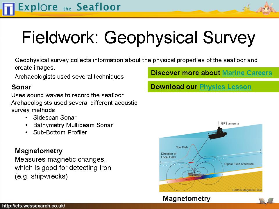
    I am the education coordinator for NOAA’s Monitor National Marine Sanctuary, and I am creating a maritime archaeology curriculum. For a section on magnetometers, I am featuring the Explore the Seafloor website as an outstanding online resource for teachers (very well done!) I would like to use a graphic from the website located on http://ets.wessexarch.co.uk/resources/imagebank/?album=5&gallery=6 It is the image at the far right, top line showing a magnetometer being towed.

    I would be most appreciative if you could direct me to whom I should request permission for usage.

    Thank you,
    Shannon Ricles
    shannon.ricles@noaa.gov
    757-591-7328 (US)

  • #3 | Written by Natasha about 9 years ago.

    coooool and lots of fun

  • #4 | Written by Maggie about 8 years ago.

    this will be cool

  • #5 | Written by Richard Hendren about 8 years ago.

    I would like your permission to use your images in an academic paper. How would you like them cited?

    Kind regards,
    Rich Hendren
    2016 Nautical Archaeology PhD Cohort
    Texas A&M University

  • #6 | Written by mark partridge about 8 years ago.

    interested in seeing more.

    The Gilberd Academy Colchester’

    Careers Convention on 4th October.
    Looking for volunteers.

  • #7 | Written by mark partridge about 8 years ago.

    When will the interactive map be available ?

    Looks a brilliant idea.

  • #8 | Written by mark partridge about 7 years ago.

    Hi, When will this be completed.

    I would like to recommend it regularly for the careers content and fun activities.

    The Gilberd Academy , Colchester.

  • #9 | Written by Annie Baker-Young about 5 years ago.

    Hi, my name is Annie and me and my friend Ellie want to be SciGirls and study the ocean floor. I think this is a really great way to, since the coranavirus and you can’t really go anywhere, let alone the bottom of the ocean. thank you for making this website and letting people all over the world study the bottom of the ocean and teaching the ways of marine biologists. Thanks again. This is super cool!

  • #10 | Written by Katia Pinheiro about 3 years ago.

    Dear Sir,

    I am Katia Pinheiro, researcher from Observatório Nacional (Brazil) and at the moment working at GFZ-Potsdam (Germany). My hobby is to produce science outreach videos. Recently I interviewed 10 female scientists (originally from 10 different countries) in Potsdam talking about themes from the core to space:
    https://www.dropbox.com/s/gsf60fog2eq9f0f/MagneticMosaic.mp4?dl=0

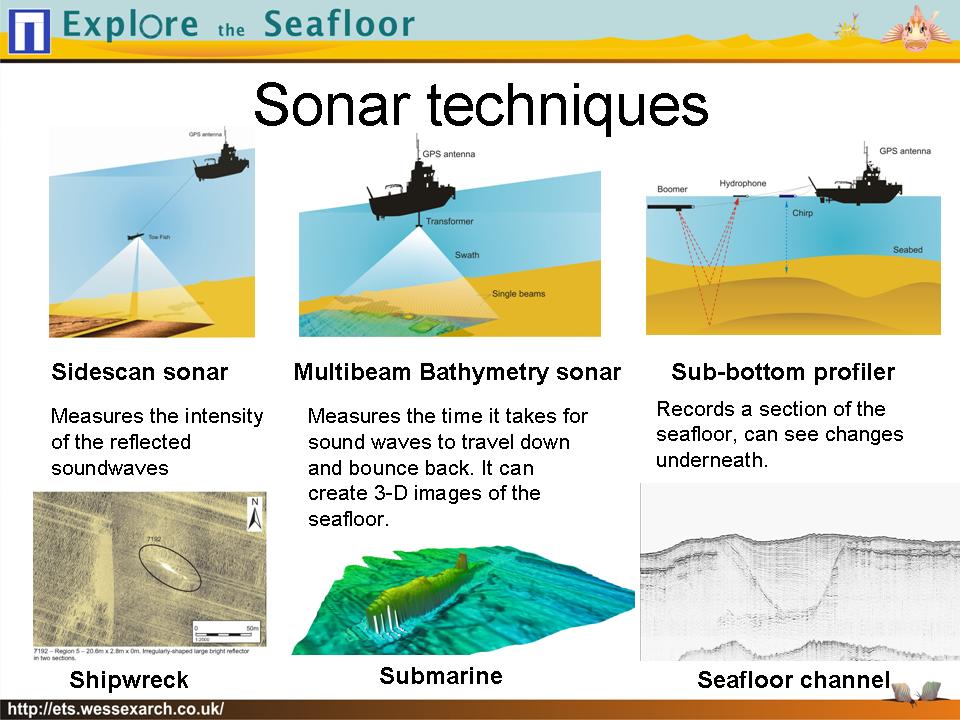
    I would like to ask if I can use your figure:
    https://ets.wessexarch.co.uk/resources/imagebank/nggallery/image-bank/how-do-we-map-the-seafloor

    in my movie (minutes: 12:39 – 12:47). In case you allow me, should I give credits like that? Figure: Li et al., 2020 – Wessex Archaeology

    I would really appreciate your contribution to my movie, which is very important to promote women in science. Thank you!

    Best wishes,
    Katia
    —
    Dr. Katia Jasbinschek Pinheiro
    Sektion 2.3, Geomagnetismus
    Phone: +49 33843 624-30
    Email: pinheiro@gfz-potsdam.de
    ___________________________________

    Helmholtz Centre Potsdam GFZ German Research Centre for Geosciences
    Adolf-Schmidt-Observatory for Geomagnetism
    Lindenstr. 7
    14823 Niemegk

  • #11 | Written by Alex Ross about 1 year ago.

    Please may you inform me when your interactive map is made available, I’d be extremely interested in submerged river channels.
    Warm regards, Alex Ross

Powered by WordPress Web Design by SRS Solutions © 2025 Explore the Seafloor Design by SRS Solutions